


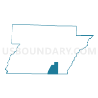
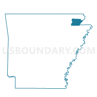
Collier Voting District, Greene County, Arkansas
About
Outline

Summary
| Unique Area Identifier | 526563 |
| Name | Collier Voting District |
| County | Greene County |
| State | Arkansas |
| Area (square miles) | 15.60 |
| Land Area (square miles) | 15.35 |
| Water Area (square miles) | 0.24 |
| % of Land Area | 98.45 |
| % of Water Area | 1.55 |
| Latitude of the Internal Point | 35.99799030 |
| Longtitude of the Internal Point | -90.50153310 |
Maps

Graphs
Select a template below for downloading or customizing gragh for Collier Voting District, Greene County, Arkansas


Neighbors
Neighoring Voting District (by Name) Neighboring Voting District on the Map
- Brookland Voting District, Craighead County, AR
- Lester Voting District, Craighead County, AR
- Mainshore Voting District, Greene County, AR
- Paragould Ward 1, Greene County, AR
- Paragould Ward 3, Greene County, AR
- St. Francis Voting District, Greene County, AR
Top 10 Neighboring County Subdivision (by Population) Neighboring County Subdivision on the Map
- Clark township, Greene County, AR (19,443)
- Brookland township, Craighead County, AR (3,146)
- St. Francis township, Greene County, AR (2,002)
- Lester township, Craighead County, AR (428)
- Collier township, Greene County, AR (377)
- Main Shore township, Greene County, AR (230)
Top 10 Neighboring Place (by Population) Neighboring Place on the Map
Top 10 Neighboring Unified School District (by Population) Neighboring Unified School District on the Map
- Paragould School District, AR (20,123)
- Greene County Technical School District, AR (18,658)
- Brookland School District, AR (8,635)
Top 10 Neighboring State Legislative District Lower Chamber (by Population) Neighboring State Legislative District Lower Chamber on the Map
- State House District 76, AR (32,719)
- State House District 78, AR (31,051)
- State House District 79, AR (24,175)
Top 10 Neighboring State Legislative District Upper Chamber (by Population) Neighboring State Legislative District Upper Chamber on the Map
Top 10 Neighboring 111th Congressional District (by Population) Neighboring 111th Congressional District on the Map
Top 10 Neighboring Census Tract (by Population) Neighboring Census Tract on the Map
- Census Tract 4806, Greene County, AR (7,307)
- Census Tract 11, Craighead County, AR (6,992)
- Census Tract 4808.02, Greene County, AR (4,004)
- Census Tract 4807, Greene County, AR (2,088)